Search This Blog

Friday, February 12, 2016

Navy Tests First ‘Reversible’ Clean Energy Fuel Cell Storage System

As reported by ComputerWorld: Boeing has announced that, after 16 months of development, it has delivered a "reversible" fuel cell for the U.S. Navy that stores energy from renewable sources and generates zero-emissions electricity.

The Solid Oxide Fuel Cell (SOFC) system, which can generate 50 kilowatts (KW) of power, is the largest of its kind and can use electricity from wind or solar power to generate hydrogen gas, which it then compresses and stores.

When power is required, the system operates as a solid oxide fuel cell, consuming the stored hydrogen to produce electricity.

The SOFC system can scale to provide up to 400KW of power. It is being tested as part of a micro power grid at the Navy's Engineering and Expeditionary Warfare Center (EXWC) at Port Hueneme, Calif., .

"This fuel cell solution is an exciting new technology providing our customers with a flexible, affordable and environmentally progressive option for energy storage and power generation," Lance Towers, director of Boeing's Advanced Technology Programs, said in a statement.

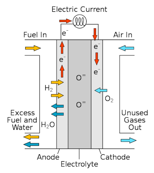
A fuel cell is a device that uses stored chemical energy (in this case, hydrogen) and converts it into electricity. The SOFC device uses solar power to strip seawater of its hydrogen molecules through electrolysis. The hydrogen gas can then be stored and later used in the fuel cell stack where it electrochemically reacts with oxygen in ambient air to produce electric current, heat and water.

solid oxide fuel cell
Omar Saadeh, a senior grid analyst at GTM Research, said the military is an enormous energy consumer with a high demand for reliability with regard to mission critical systems; so it only makes sense that they'd invest in a combination of on-site power generation and microgrid technologies.

"At forward operating bases, for example, deploying renewables not only enhances energy efficiency, but more importantly, also reduces the logistical risk in transporting fuel over distant and often hostile territory," Saadah said in an email reply to Computerworld.

Microgrids are small-scale power infrastructures that operate autonomous from the centralized grid run by utilities. According to a 2015 microgrid study by GTM Research, the military made up 35% of U.S. operational microgrid capacity.

While solar power is often promoted as the resource of the future, natural gas-fired generation accounts for 67% of the military’s domestic microgrid energy generation, Saadah said.

"This is due to its rapid dispatchability and reliability as a larger-scale power source," he said. "That being said, remote bases, which are smaller by nature, are deploying renewable and storage combinations as economically viable solutions that to meet today’s energy needs."

The SOFC manufacturers include Boeing in Huntington Beach, Calif. and Sunfire in Dresden, Germany.

The technology is unique in being able to both store energy and produce electricity in a single system, making the technology "reversible," Boeing said.

"The SOFC is a most promising technology for both remote islands and expeditionary applications," Michael Cruz, EXWC project manager, said in a published report. "Combined with a solar photovoltaic array, a SOFC system generates electricity, potable water, and heat with only two inputs, sunshine and seawater."

Wednesday, February 10, 2016

In Boost to Self-Driving Vehicles, U.S. Tells Google Computers Can Qualify as Drivers

As reported by ReutersU.S. vehicle safety regulators have said the artificial intelligence system piloting a self-driving Google car could be considered the driver under federal law, a major step toward ultimately winning approval for autonomous vehicles on the roads.


The National Highway Traffic Safety Administration told Google, a unit of Alphabet Inc, of its decision in a previously unreported Feb. 4 letter to the company posted on the agency's website this week.
Google's self-driving car unit on Nov. 12 submitted a proposed design for a self-driving car that has "no need for a human driver," the letter to Google from National Highway Traffic Safety Administration Chief Counsel Paul Hemmersbaugh said.
"NHTSA will interpret 'driver' in the context of Google's described motor vehicle design as referring to the (self-driving system), and not to any of the vehicle occupants," NHTSA's letter said.
"We agree with Google its (self-driving car) will not have a 'driver' in the traditional sense that vehicles have had drivers during the last more than one hundred years."
Major automakers and technology companies such as Google are racing to develop and sell vehicles that can drive themselves at least part of the time.
All participants in the autonomous driving race complain that state and federal safety rules are impeding testing and eventual deployment of such vehicles. California has proposed draft rules requiring steering wheels and a licensed driver in all self-driving cars.
Karl Brauer, senior analyst for the Kelley Blue Book automotive research firm, said there were still significant legal questions surrounding autonomous vehicles.
But if "NHTSA is prepared to name artificial intelligence as a viable alternative to human-controlled vehicles, it could substantially streamline the process of putting autonomous vehicles on the road," he said.
If the car's computer is the driver for legal purposes, then it clears the way for Google or automakers to design vehicle systems that communicate directly with the vehicle's artificial pilot.
In its response to Google, the federal agency offered its most comprehensive map yet of the legal obstacles to putting fully autonomous vehicles on the road. It noted existing regulations requiring some auto safety equipment can not be waived immediately, including requirements for braking systems activated by foot control.
"The next question is whether and how Google could certify that the (self-driving system) meets a standard developed and designed to apply to a vehicle with a human driver," NHTSA said.
Google is "still evaluating" NHTSA's lengthy response, a company spokesperson said on Tuesday. Google executives have said they would likely partner with established automakers to build self-driving cars.
WORRIES ABOUT PEOPLE UNDERMINING SAFETY
Google told NHTSA that the real danger is having auto safety features that could tempt humans to try to take control.
Google "expresses concern that providing human occupants of the vehicle with mechanisms to control things like steering, acceleration, braking... could be detrimental to safety because the human occupants could attempt to override the (self-driving system's) decisions," the NHTSA letter stated.
NHTSA's Hemmersbaugh said federal regulations requiring equipment like steering wheels and brake pedals would have to be formally rewritten before Google could offer cars without those features.
For example, current federal rules require alerts on dashboards if tire pressure runs low. NHTSA said a test would need to be created that shows the vehicle computer is informed of the problem. NHTSA raised the question of whether humans in the vehicles should also be made aware.
In January, NHTSA said it may waive some vehicle safety rules to allow more driverless cars to operate on U.S. roads as part of a broader effort to speed up development of self-driving vehicles.
NHTSA said then it would write guidelines for self-driving cars within six months. Transportation Secretary Anthony Foxx said the administration may seek new legal authority to allow deployment of autonomous vehicles "in large numbers," when they are deemed safe, the department said.
The process of rewriting federal regulations governing the design, placement and operation of vehicle controls could take months or years. The NHTSA counsel said Google could consider applying for exemptions for certain regulations, providing NHTSA with supporting documents.
(Reporting by Paul Lienert in Detroit and David Shepardson in Washington; Editing byCynthia Osterman)

Tuesday, February 9, 2016

MIT Shows Off Power Efficient Chip Designed for Artificial Intelligence

A team of US researchers has built an energy-friendly chip that can perform powerful artificial intelligence (AI) tasks, enabling future mobile devices to implement “neural networks” modeled on the human brain.
As reported by Hindustan TimesThe team from Massachusetts Institute of Technology (MIT) developed a new chip designed specifically to implement neural networks.
It is 10 times as efficient as a mobile GPU (Graphics Processing Unit) so it could enable mobile devices to run powerful AI algorithms locally rather than uploading data to the Internet for processing.
The GPU is a specialized circuit designed to accelerate the image output in a frame buffer intended for output to a display.
Modern smartphones are equipped with advanced embedded chip-sets that can do many different tasks depending on their programming.
GPUs are an essential part of those chip-sets and as mobile games are pushing the boundaries of their capabilities, the GPU performance is becoming increasingly important.
Neural nets were widely studied in the early days of artificial intelligence research, but by the 1970s, they had fallen out of favor. In the past decade, however, they have come back under the name “deep learning.”
“Deep learning is useful for many applications such as object recognition, speech and face detection,” said Vivienne Sze, assistant professor in MIT’s department of electrical engineering and computer science, in a MIT statement.
The new chip, which the researchers dubbed “Eyeriss,” can also help usher in the “Internet of things” – the idea that vehicles, appliances, civil-engineering structures, manufacturing equipment, and even livestock would have sensors that report information directly to networked servers, aiding with maintenance and task coordination.
With powerful AI algorithms on board, networked devices could make important decisions locally, entrusting only their conclusions, rather than raw personal data, to the Internet.
The team presented their findings at the “International Solid State Circuits Conference” in San Francisco recently.
At the conference, the MIT researchers used “Eyeriss” to implement a neural network that performs an image-recognition task. It was for the first time that a state-of-the-art neural network has been demonstrated on a custom chip.
“This work is very important, showing how embedded processors for deep learning can provide power and performance optimizations that will bring these complex computations from the cloud to mobile devices,” explained Mike Polley, senior vice president at Samsung’s mobile processor innovations lab.

Monday, February 8, 2016

Google Is Testing Wireless Charging for Its Self-Driving Cars

As reported by FortuneGoogle parent-company Alphabet is testing at least two wireless charging systems for its electric-powered self-driving cars.

Documents filed with the U.S. Federal Communications Commission reveal Google is testing two wireless charging systems for its self-driving cars, reported IEEE Spectrum. Startup Hevo Power received permission in February 2015 to install an experimental charger at Google’s Mountain View, Calif. headquarters. Momentum Dynamics received permission in July, according to the filings.
Google wouldn’t comment to Fortune except to say it tests a variety of technologies.
This isn’t the first wireless charging system Google has tested. Back in 2011, the company tested a prototype of Plugless, a wireless charging system developed by Evatran. The Hevo and Momentum Dynamics systems appear to be the first tested on the self-driving prototype Google introduced in June 2015.
Wireless charging could help accelerate the adoption of individually owned electric vehicles. However, Google has a different motivation. The company probably won’t sell its self-driving cars to individuals. Instead, it will likely deploy its self-driving cars as a transportation service that users can order via an app.
For example, Google self-driving cars—which don’t have pedals or a steering wheel, only sensors and software—could be stationed in various clusters around a town or closed campus. Each corral of self-driving cars could be outfitted with wireless charging, which would eliminate the need for a human attendant to plug the cars in.
Google hasn’t provided detailed plans for its self-driving car program, which started in 2009. Google has said it wants to commercialize self-driving cars by 2020. Chris Urmson, director of the program, has repeatedly talked about the self-driving cars being used by children, the disabled, or others who might not be able to drive a car manually—another reason to use wireless charging.
Google blames humans for self-driving car crashes
Other companies are pursuing wireless charging, including Qualcomm. Evatran’s Plugless, which has completed field trials with Google, Hertz, SAP, and Duke Energy, began selling directly to EV owners in the U.S. and Canada in March 2014. Plugless supports wireless charging for the Chevy Volt, Nissan LEAF, and Cadillac ELR EVs. Chinese automotive parts manufacturer Zhejiang VIE Science and Technology Company recently invested $3.2 million into Evatran as part of a $10 million Series B funding round that will help it expand in North America and China.
Meanwhile, Tesla has developed a different kind of charger that doesn’t require a person to plug it in. The metal snake-like charger prototype, which Tesla showed in a video in August 2015, automatically connects to the all-electric vehicle.

Russia Launches First GLONASS-M Navigation Satellite in More Than a Year

As reported by Inside GNSSIn its first GLONASS-M launch in more than a year, Russia lifted a satellite into orbit yesterday (3:21 a.m. Moscow time, February 7, 2016) from the Pletsetsk Cosmodrome, after being postponed from December.

GLONASS-M #51 (GLONASS constellation designation #751) will replace a 10-year-old satellite (GC#714) that ceased operations last October in slot 17, orbital plane 3 of the constellation.
The satellite reached orbit aboard a Soyuz-2.1b rocket with a Fregat upper stage. Three and a half hours from the lift off the satellite separated from the upper stage and ground control established communications with it, according to Information Satellite Systems (ISS) – Reshetnev Company, which built the spacecraft.
According to the telemetry data received from GLONASS #51, the satellite is in good health, Reshetnev said in a news release. “With all its mechanical subsystems successfully deployed, the satellite completed Earth and Sun acquisition. The Moscow-based System Control System and ISS-Reshetnev’s Information and Computation Center have already begun satellite’s performance check-out.” 

Eight launch-ready GLONASS-M navigation satellites are currently stored at ISS-Reshetnev Company.

GPS and the World's First "Space War"

As reported by Scientific AmericanTwenty-five years ago U.S.-led Coalition forces launched the world’s first “space war” when they drove Iraqi troops out of Kuwait. Although the actual fighting did not take place in the upper reaches of the atmosphere, satellite-based global positioning systems (GPS) played a critical role in the Coalition’s rapid dismantling of Saddam Hussein’s military during the 1991 Persian Gulf War. Without their orbiting eyes in the sky U.S. troops in particular would have had a much more difficult time navigating, communicating and guiding their weapons across the hundreds of kilometers of inhospitable, windswept desert battlefields in Kuwait and Iraq.


GPS would change warfare and soon became an indispensable asset for adventurers, athletes and commuters as well. The navigation system has become so ubiquitous, in fact, that the Pentagon has come full circle and is investing tens of millions of dollars to help the military overcome its heavy dependence on the technology. GPS’s relatively weak signals are often unreliable and susceptible to interference, also known as “jamming.” This has prompted the Defense Advance Research Projects Agency (DARPA) to begin developing navigational aids that function when satellite access is unavailable.

“Where am I?”

In January 1991, months after Iraq’s
 invasion and occupation of neighboring Kuwait put the international community on alert, the U. S. and more than a dozen other countries launched Operation Desert Storm. The weeks-long air offensive unleashed stealth bombers, cruise missilesand laser-guided “smart” bombs on Iraq’s communications networks, weapons plants and oil refineries. Clearing Hussein’s forces out of Kuwait, however, required ground fighting, a daunting prospect for the Coalition members unaccustomed to desert warfare. “The introduction of GPS was particularly timely for U.S. forces in the Gulf War, primarily to address the age-old question of where am I, and where am I going?” says Col. Anthony Mastalir, vice commander of the 50th Space Wing, U.S. Air Force Space Command based at Schriever Air Force Base in Colorado. Schriever houses the master control station used to determine U.S. GPS satellite orbits and update their navigation instructions. “That information is especially important when you have very few landmarks or reference points as the troops did."

The U.S. military faced several challenges when the ground campaign began on February 24, 1991. For starters, U.S. Army artillery units assigned to fire missiles on enemy defenses and clear the way for infantry troops historically required a day or so to survey a battlefield and set up munitions. This would not be the case in Kuwait as the infantry’s armored tanks, trucks and other vehicles moved swiftly, capable of travelingupward of 50 kilometers per hour. Such speeds would require artillery guns to be quickly set up, fired and moved to the next site. Failure to do that meant the infantry would not get enough artillery support in advance of engaging the Iraqis. Fears that the enemy would resort to chemical weapons against the Coalition’s infantry only accentuated the need for efficient artillery cover. The Pentagon was counting on GPS to help solve this problem.

Another challenge involved a key component of the U.S.’s ground strategy—moving infantry and artillery into even less hospitable areas of the desert in order to outflank and encircle Iraqi forces. GPS would be crucial to helping ground troops “navigate through terrain that the Iraqis weren’t bothering to defend because they didn’t think anyone could find their way through there,” says Marc Drakea retired U.S. Air Force major who served as chief of operational analysis for the 2nd Space Operations Squadron during the Gulf War. The squadron operates Schriever’s master control station as well as the network of worldwide monitoring stations and ground antennas that control and support the U.S.’s GPS satellite constellation.

Mom and dad, please send GPS

The Army’s decision to rely on GPS was a big gamble. A fully operational GPS constellation requires 24 satellites, something the U.S. would not achieve until April 1995. In early 1991 the U.S. Air Force’s Navstar (Navigation System Using Timing and Ranging) constellation included only 16 satellites, and six of those were older research and development units repurposed to help with the war effort. Unlike today’s 24/7 GPS coverage, the satellites in the original Navstar constellation could align long enough to provide about 19 hours each day. Accuracy would be within 16 meters, give or take, better than earlier GPS systems that had a several kilometers margin of error but not quite on par with today’s to-the-centimeter precision.

Signal issues aside, GPS receivers were also in short supply. For starters, there were only 550
 PSN-8 Manpack GPS receivers to go around. Troops fortunate enough to be issued Manpacks mounted these eight-kilogram devices—which cost $45,000 apiece—to their vehicles. A second, more portable option was the 1.8-kilogram AN/PSN-10 Small Lightweight GPS Receiver (SLGR), or “slugger.” The military had about 3,500 of the Trimble Navigation–made SLGR devices available for use in the Gulf War. “You would hear stories about Air Force, Navy and Army personnel having mom and dad send them civilian GPS receivers so they could find their way out there,” says Drake, who currently serves as a space vehicle operations support manager at Schriever. They would fasten the devices to their Humvees or tanks using Velcro, screws or duct tape as they maneuvered through unfamiliar territory. One of the most popular was the $3,000 NAV 1000M Receiver, which Magellan Corp. had been selling to boaters, hikers and other adventurers since the late 1980s.

How GPS works

GPS consists of three components: satellites, receivers and ground control stations. Navstar currently has 31 operational satellites that orbit at about 20,000 kilometers above Earth every 12 hours. The constellation uses six equidistant orbital planes, with four satellites in each plane, Mastalir says.GPS satellite signals carry a time code marked by their atomic clocks, which essentially keep time by measuring the oscillations of atoms. The clocks enable each satellite in the Navstar constellation to continuously broadcast a signal that includes the time and the satellite’s exact position.


GPS receivers—whether they are installed in ships at sea or embedded in wristwatches—calculate their latitude, longitude and altitude by measuring the relative time delay of signals broadcast by at least four different satellites. Ground control, meanwhile, consists of five monitoring stations, three ground antennas and Schriever’s master control station, which communicates with the satellites via the ground antennas.

Navigating victory

Although GPS accuracy and reliability today is a lot better than it was 25 years ago, the coalition’s gamble paid off. During the ground war, which lasted only about 100 hours, GPS receivers helped greatly with land navigation and artillery support, which was part of the massive bombardment that Iraqi soldiers referred to as “
steel rain.” GPS supplemented or even replaced the artillery surveyor’s compass, telescopelike aiming circle, slide rule and other tools of the trade. GPS was also at the heart of new artillery weapons including the Army Tactical Missile System, which debuted during the Gulf War, had a range of about 270 kilometers and used Navstar satellite guidance to home in on its targets.


A NAVSTAR GPS SATELLITE UNDERGOING PRE-LAUNCH TESTING.
COURTESY UNITED STATES AIR FORCE.

Satellite-based navigation proved its mettle in helping the U.S. Army’s VII Corps and XVIII Airborne Corps initiate a flanking maneuver—which different military leaders called the “Hail Mary” or “left hook”—in which troops navigated far to the west of the point in southern Kuwait where the Iraqis expected coalition forces to attack. With only 3,000 GPS devices available for its contingent of 40,000 tanks, Bradley fighting vehicles, howitzer guns and cavalry, the Army units advanced more than 200 kilometers in two days through largely uncharted desert before engaging the Iraqi Republican Guard in the decisive Battle of 73 Eastingon February 26. The battle’s name provides some insight into how much the coalition relied on advanced navigational aids just to reach the enemy—“73 easting” is a north–south line on a map in the middle of the desert as opposed to a town, roadway or some other physical reference point.

GPS jamming

Coalition troops also got a glimpse of GPS’s greatest weakness during the Gulf War. Iraqi forces installed jammers, for example, on top of landmarks such as Saddam Hussein’s palaces to prevent them from being hit, Mastalir says. This helped the military realize early on that it would have to further develop its laser-guided munitions and other weapons that acquire targets when GPS is unavailable, he adds. Jamming disrupts a receiver’s ability to pick up data from the satellites by adding more noise to the signal transmission. Tinkering with the signal-to-noise ratio is not difficult, given how weak GPS signals generally are by the time they reach Earth. Such signals have been compared with the amount of light given off by a
 25-watt bulb, as seen from about 20,000 kilometers away.

Jamming can, to some degree, be countered by increasing signal strength and using antennas that can better discriminate between signal and noise. At the same time, however, the Pentagon recognizes the danger of relying too heavily on satellite-based GPS. DARPA, which helped miniaturize GPS receivers in the 1980s and developed ways to add GPS guidance to munitions, is now investing in new types of inertial and self-calibrating sensors that could continue to accurately track a receiver’s position when satellite service is not an option. This includes the $50-million Atomic Clocks with Enhanced Stability (ACES) program to develop portable, battery-powered atomic clocks the size of cell phones. The goal is for the next generation of clocks to be 1,000 times more stable than current models and to accurately maintain time and navigation information in devices even when cut off from satellite communications.

If DARPA’s vision comes to fruition, military units could someday be equipped with both
atomic clocks and GPS receivers to help them find their way through hostile territory.

Friday, February 5, 2016

US Air Force Launches GPS Satellite to Complete Navigation Constellation

As reported by Space.com: The final addition to a group of global positioning satellites successfully launched into orbit this morning.

The GPS IIF-12 satellite took off today (Feb. 5) aboard an Atlas V 401 rocket from Complex 41 at Cape Canaveral Air Force Station in Florida at 8:38 a.m. EST (1338 GMT). The satellite was built by Boeing, and is operated by the U.S. Air Force. It is the 12th and final block IIF global positioning system satellite to launch.

"This is a significant milestone for GPS, the 50th GPS satellite to be delivered on-orbit," said Lt. Gen. Samuel Greaves, Space and Missile Systems Center commander and Air Force program officer for space, in a statement from Patrick Air Force Base in Cape Canaveral. "The GPS IIF satellite performance has been exceptional and is expected to be operational for years to come."

The Atlas V rocket is built by United Launch Alliance (ULA), a joint venture between Boeing and Lockheed Martin. As with previous IIF satellite launches, the rocket was in a 401 configuration, which consists of a 4.2-meter (13.7 feet) payload fairing and two booster stages.

GPS satellites fly at an altitude of about 12,550 miles (20,200 km), and provide global positioning, navigation and timing services to both civilians and military personnel.

The IIF-12 launch date was initially delayed when ULA officials were alerted to a possible problem with electrical connectors in the Atlas V booster. In a media briefing Jan. 29, Walter Lauderdale, the GPS IIF-12 mission director, said the problem was fully investigated and solved, but delayed the launch by "a couple of days."

"We took the time to inspect all the subject connectors and verified the integrity of those connectors," Lauderdale said. "Frankly, a day or two delay cannot possibly compare to the loss of a vital national asset. That is the nature of a sharp focus on mission success."

Built by Boeing, the $131 million satellite will join a constellation of 30 other operational GPS satellites, the first of which was launched in 1990. The "Block II" family of satellites have consisted of the IIA series, followed by the IIR series, and the IIF series. The first IIF satellite was launched in 2010, and the GPS-11 satellite was launched on Oct. 31, 2015. The IIF-12 satellite is the last in the IIF series, and Boeing is already working on an IIIF series of satellites to join the GPS constellation.

During a live broadcast of the launch, Dan Hart, vice president of government satellite systems for Boeing, spoke about the improvements of the IIF series from previous series used in this GPS constellation. According to Hart, the IIF satellites have improved clocks; a jam-resistant military signal; and a new, dedicated civilian signal that is particularly useful for commercial aviation and search-and-rescue operations.